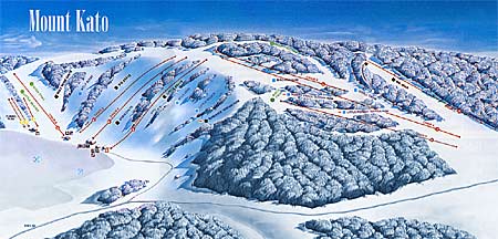
The map trailmarking symbols for most difficult, more difficult and easiest are relevant to Mount Kato Ski Area's ski trails only.
Be advised that all poles and/or flags, signage and covers on equipment or objects or other forms of marking devices are used by the ski area to inform you of the presence or location of a potential obstacle or hazard. These markers are no guarantee of your safety and will not protect you from injury. It is part of your responsibility under the Skiers' Responsibility Code to avoid all obstacles or hazards, including those that are so marked.
Mount Kato Ski Area 20461 State Hwy 66, Mankato, MN 56001 (800) 668-5286
